PFD & Synthetic Vision
The primary flight display: tapes, flight director, HSI with bearing pointers, minimums and alerting, and WebGL synthetic vision beneath it all.
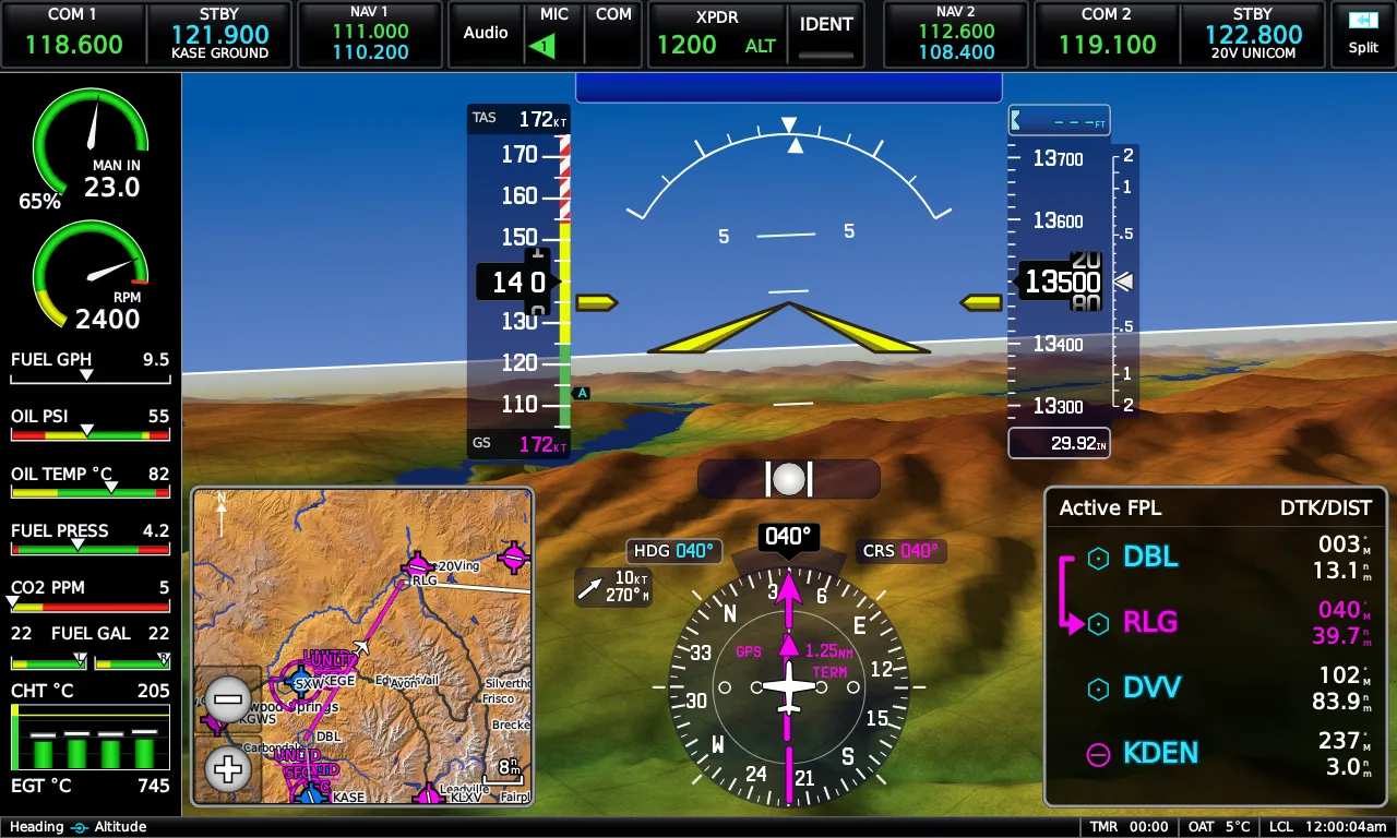
Tapes and bugs
Section titled “Tapes and bugs”Airspeed on the left, attitude in the center, altitude and VSI on the right, HSI below. Every PFD readout is a live control: touch the heading, altitude, baro, course, or minimums field and a numeric keypad opens for it — Select Heading, Select Altitude, Baro Setting, and so on. The knobs edit the same values in real-unit steps: selected altitude in 100 ft increments, baro in 0.01 inHg detents.
The course field is a button whenever the course is actually pilot-set — a VLOC course, GPS OBS, or a Direct-To user course. In normal GPS navigation the course comes from the flight plan and the field isn’t editable, exactly like the real unit.
Attitude and flight director
Section titled “Attitude and flight director”The flight director’s command bars are computed by the E3X itself — they show what the AFCS is asking for, whether or not your aircraft’s autopilot is engaged.
- CDI Source — touch the attitude indicator or HSI (or press MENU on a full-screen PFD) to open PFD Options, then touch CDI Source to cycle GPS → NAV1 → NAV2. The value tints magenta for GPS, green for VLOC.
- Bearing pointers — two independent pointers, each set from a dropdown in PFD Options: Off, GPS, VLOC, Best Airport, or Nearest Airport.
- Radios you’ve disabled in Setup → Radios drop out of the CDI and bearing-source choices automatically.
- HSI Orientation can be fixed heading-up or Auto TRK/HDG, which switches the rose to track-up in cruise. CDI Scale offers 0.25, 1.25, and 5.00 nm full-scale.
The PFD Options window
Section titled “The PFD Options window”Touching the attitude indicator or HSI opens PFD Options: FPL source, CDI source, the two bearing-pointer dropdowns, a G-meter reset, a start/stop/reset timer, the minimums box, and More Options… which opens the full PFD Setup window.
Minimums and altitude alerting
Section titled “Minimums and altitude alerting”Set a barometric minimum from the Minimums box in PFD Options — the keypad’s Clear disables it again. The value shows as a BARO MIN readout on the PFD with a bug on the altitude scale, and the alert steps through approaching / reached states as you descend. Minimums are set per flight — they reset at power-up, like the real unit.
Selected-altitude alerting is automatic: approaching cues at 1000 ft and 200 ft to capture, then a deviation alert if you leave the captured altitude by more than 200 ft.
Synthetic vision
Section titled “Synthetic vision”WebGL terrain under the attitude display: hypsometric shading with hillshade, water with real shorelines, and runways drawn in perspective — outlined deck, dashed centerline, threshold numbers. Terrain that threatens your flight path picks up the Terrain page’s red/yellow shading, restricted to a forward corridor along your track so the picture stays calm in normal flight, and inhibited close to the airport so short final isn’t a wall of red.
Pathways draws the active flight plan as a corridor of boxes at your selected altitude — magenta for the active leg, white for the rest — when GPS is the nav source.
Synthetic vision and its sub-layers (pathways, flight-path marker) toggle in PFD Setup. If attitude, heading, position, or terrain data ever goes invalid, the PFD reverts to the classic blue-over-brown presentation on its own and comes back when the data does.
Round-gauge mode
Section titled “Round-gauge mode”PFD Setup → PFD Presentation → Round Gauges swaps the tapes for a classic six-pack presentation: round airspeed and altitude dials with a digital drum, a D-shaped VSI, a repositioned HSI, and a ball-in-tube inclinometer — over the same attitude and synthetic vision.
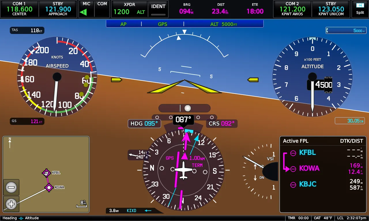
PFD Setup
Section titled “PFD Setup”Main Menu → Setup → PFD (or More Options… from PFD Options): PFD presentation, wind vector style, standard-rate bank pointers, HSI orientation, CDI scale, pitch offset, baro transition altitude, a G-meter that can replace the HSI (with automatic display on high load factor or unusual attitude), lateral deviation and trim/flap indicators, and the synthetic-vision toggles.
Emrelia E3X is an independent product of Emrelia LLC. It is not affiliated with, endorsed by, or sponsored by Garmin Ltd. or its affiliates. G3X Touch™ is a trademark of Garmin Ltd. For flight simulation use only — not for use in real-world navigation. Map imagery contains data © OpenStreetMap contributors (ODbL) and other sources — see data attributions. © 2026 Emrelia LLC.